Can Chemtrails be proved?
May 26 2011 - This is an appeal for cooperation from G. Edward Griffin (see his Reality Zone Site) which I would like to make available here ... perhaps one or the other of my readers is interested in the chemtrail phenomenon and would like to contribute to ending any uncertainty that still surrounds this "painted skies" mess.
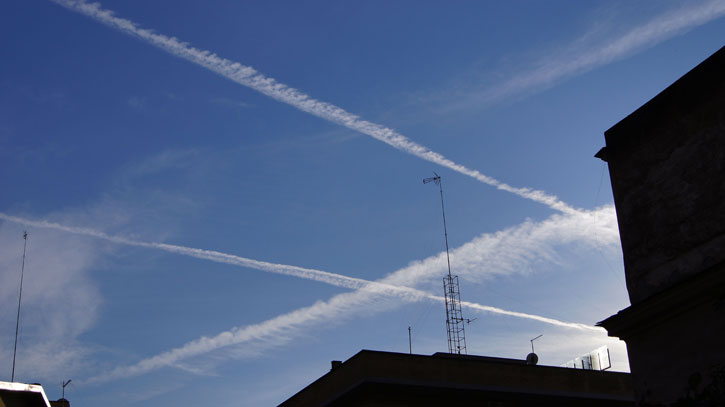
Image: Chemtrails over Rome - December 29, 2010
INVESTIGATORS WANTED
Can Chemtrails be proved?
It seems that the die-hard skeptics refuse to believe what they see with their own eyes. No matter how many laboratory tests we collect, they always seem to come up with a theory that, no matter how far fetched it is, would explain the high levels of aluminum, barium, and strontium as merely due to some climate condition or error in preparing the chemical sample or some unintended human interaction.
SKI SLOPE THEORY
When we released our documentary, What in the World Are They Spraying, we included snow samples taken from Mt. Shasta in Northern California, which contained toxic levels of these metals. Since snow is merely frozen rain water, it was clear that this came from the sky and not from the soil or water run-off from some toxic waste dump. Nevertheless, an Internet debunker challenged our conclusion by claiming that people ski on Mt. Shasta, and skis are made of aluminum. Therefore, the tested aluminum probably came from the skis! Nothing to worry about after all.
Of course, this was all made-up nonsense. People do ski on Mt. Shasta, but it is a big mountain, and there has never been any skiing in the area where the samples were taken. Even if there had been, that would not explain the high levels of barium and strontium. These metals are not used in the construction of skis. Our debunker never bothered to check on any of that. He was merely looking for some plausible explanation in order to plant doubts into the minds of casual readers. If people are confused by seemingly plausible explanations that even remotely could explain away the high levels of aluminum, barium, and strontium in snow and rain water, they will back away from coming to a conclusion and align themselves with the prevailing view.
DUST-BOWL THEORY
Another debunker contacted me a few days ago and claimed that a plausible explanation for the chemicals in snow on Mt. Shasta is that the samples were taken in a year with early snow melt which, according to him, means there was a lot of bare earth exposed at the time, and the wind must have blown dust from the earth onto the snow. Furthermore, he claims that the soil on Mt. Shasta contains the same metals as found in the samples; so, you see? Here is another perfectly plausible explanation. Once again, nothing to worry about.
We are planning to respond to this gentleman as soon as we can find the time to carefully examine his claims about the early snow melt, the amount of bare earth exposed, the composition of the surface soil, and especially the rainfall and moisture levels of the soil during this period. I expect to find that, even if there had been an early snow melt, the soil on Mt. Shasta would have been far too moist and covered with moss, ferns, or other ground cover to make the "dust-bowl" theory even remotely plausible. But it will take a little time to pull the facts together.
Meanwhile, we must not just play defensive and spend our lives answering the debunkers. We must take the initiative and obtain new data and information that will be impossible to dispute. The on-going collection of new snow and rain samples is part of that strategy. After we have literally hundreds of such chemical tests, I think our critics will run out of plausible-denial theories.
PLANE FINDER
One of the most promising technologies to generate hard evidence of chemtrails is the Internet tracking of planes in flight. There are several computer programs and devices that track commercial flights in real time and show, not only their location, but also their flight number, type of aircraft, origin, destination, speed, and altitude. The cost for this App on an iPhone is about $4, and on a computer, it is free. This is amazing technology, and the programs actually are fun to use. They work by receiving what is called ADS-B plane feeds, which are radio signals transmitted by commercial and private aircraft. Military aircraft and those on classified missions do not transmit this signal.
I'm sure you already see where this is going. It is theoretically possible to identify every commercial plane you see overhead either by pointing your iPhone camera at it or locating it on the screen of your computer. If the debunkers are correct, we will find that planes spewing a trail from horizon-to-horizon will all be identified as merely commercial craft and what we see are merely normal contrails after all. On the other hand, if we find that commercial craft do not leave streaks from horizon to horizon but the ones that do are missing from the system ... well, even the most die-hard skeptic would have to take a serious look at that.
- - -
To be sure, the debunkers will always be able to find some semi-plausible explanation for everything, even this. For example, not all parts of the world or even of the United States are serviced by this technology at the present time, although the most populated areas are. So the debunkers will likely claim that the coverage is not complete and, therefore, not reliable. Also, there is some question about whether all commercial planes are equipped with these transmitters or merely most of them, so the debunkers will claim that a plane that does not show up in the system is probably just one of those commercial planes without transmitters. One blogger who is not happy with the technology claims that his iPhone does not work if the plane is closer than 50 miles, supposedly because of some interference by Homeland Security to protect planes from terrorists. (I do not have an iPhone so I cannot verify his claim, but I had no trouble tracking aircraft directly overhead when using the full computer version of Plane Tracker.) In any event, debunkers will claim that the system is filled with quirks and errors and is not reliable ... you get the picture.
In spite of the debunkers, there is an opportunity here to collect data that will be very compelling, even if there are areas not serviced by the technology and even if a small percentage of commercial planes are, in fact, without transmitters. If we can demonstrate that most flights with long trails are missing from the system, I think we will have put the final nail into the coffin of chemtrail denial.
TWO-EDGED SWORD
This project is a two-edged sword. What if we find that all those trails really are coming from the same scheduled planes that carry passengers? That would mean we have been on the wrong track, and we would have to re-examine our evidence and re-consider our position. There are some who are convinced that spraying is done by planes performing routine commercial services, but I have not considered that to be likely in view of the huge amount of chemicals needed for such missions and the difficulty in concealing the mixing of chemicals with jet fuel, to say nothing of the effect it would have on fuel performance and damage to the engines. Furthermore, Planes that fly in the crazy patterns we have seen would hardly go unnoticed and unreported by passengers. In any event, the results of a field test such as I am proposing will clear up many of these questions.
Here is what I am asking you to do. If this project interests you, please go on the Internet and become familiar with a program called Plane Finder.
Play with it a while to see how you can track aircraft anywhere in the world, provided there are receiving stations in that area. When you see on your screen that a plane is moving over your location, you should be able to go outdoors and watch it in the sky. Every time you see a plane, get its identity from Plane Finder and note if it has very long trails (lingering over more than half the sky and feathering out into a lingering milky haze), short trails (moving along with the aircraft and dissipating as they go), or no trails (usually low altitude flights). Record all the data about the flight including the time.
For those with iPhones or other smart phones that can handle the Plane Finder App, purchase it and install it. Then, every time you see a plane, aim the camera lens of the phone at the plane and record its identification, including the time.
That's it. If 50 or 100 people will do this, and if they are able to collect data on flights over a one-month period, we will have a data base of immense value. When complete, please prepare a summary, including the locations where observations were made and a brief summary of your experience, and send it to me at
Are we going to have fun or what?
Ed Griffin
P.S. If you have not yet obtained a copy of What in the World Are They Spraying, there is no better time than now. It can be ordered here:
What in the World Are They Spraying?
There is also a version on YouTube. Much lower quality, but if you can't buy right now...
What in the World Are They Spraying? (Full Length)
... and there is another, more recent documentary titled WHY in the world are they spraying. I recommend seeing it.
CHEMTRAIL UPDATE #2
(update number 1 was directly incorporated into the article)
Choice of Tracking Programs
The first few days of experience with tracking live flights has been highly instructional, and we have had some surprises. One of them is that Plane Finder is not the best program for tacking commercial aircraft in the United States or Canada. There are numerous areas with high levels of air traffic, such as Las Vegas, that show no aircraft at all on their maps. In Canada, only a few routes along the southern border are included. Other parts of the world, except Europe, seem to be similarly blank.
I think the reason for this is that the company is still in the process of adding data receivers to its network, and these areas are not yet included. While scanning the Internet for more information, I came across a posting from Pinkfroot, the company that owns this software, offering to provide free receivers to private parties in North America who were willing to share the data with the company. That was posted on July 4, 2010, and there were numerous responses from private parties offering to help build the network. I don't know if the company still is offering receivers on this basis, but I mention it because it suggests that their coverage may still be in expansion mode.
When I checked out Plane Finder where I live in the greater Los Angeles area, the program picked up a large number of flights, and I was able to go outside and verify visually that what was on my computer screen actually was flying overhead. It was on that basis that I thought we were in good hands with this program.
There are two other tracking programs that have better coverage than Plane Finder. They are Flight Explorer and Flight Aware. Flight Explorer (Personal Edition) costs $10 a month for ten hours usage plus a small fee for each additional hour. Flight Aware is free. They are relatively easy to use if you are willing to spend about fifteen minutes exploring their features and controls. If you live in an area where Plane Finder does not work, you probably will find that one of these programs will.
There is, however, a drawback to both. According to the information provided on their web sites, flight data is delayed by five minutes because of FAA requirements. Only government and commercial users are able to access this data in real time. That means that what you see in the sky will not show up in the tracking program until five minutes after you see it. That is not too difficult to work around insofar as keeping records. It just means you have to be a bit patient.
Plane Finder says its images are displayed in "near real time." As far as I can tell with flights passing over my house (I am under a major air-lane into Los Angeles), the images either are in real time or within a minute of it. I don't know why Plane Finder displays flights so close to real time when others services are not allowed to do so, but I think it may be because it takes its flight data from a different source.
Plane Finder says it derives its flight data from radio signals constantly generated from each aircraft. These are called ADS-B plane feeds. This is not the same as signals from aircraft transponders. That is another type of identification altogether. Wikipedia says that a transponder "is an electronic device that produces a response when it receives a radio-frequency interrogation. In aviation, aircraft have transponders to assist in identifying them on radar and on other aircraft's collision avoidance systems. Air traffic control units use the term "squawk" when they are assigning an aircraft a transponder code." The reason we have created a place on our data sheets for "Squawk" is to make a record of each plane's transponder code.
So, what is the difference between a transponder signal and an ADS-B plane feed, and why are there two systems? As far as I can tell (I trust I will be soundly corrected if I am wrong, in which case I will pass along the correction), there are three differences." (1) Transponders send out signals only when they are contacted by a radio request, while ADS-B is constantly broadcasting; (2) Transponders have a wide range of responses available depending on the nature of the request, while ADS-B transmits only one set of information; and (3) transponders are used in larger planes and commercial flights, not available to everyone, while ADS-B is a kind of poor-man's system, available to anyone who wants to have the safety benefits of being electronically visible to other aircraft.
According to Commercial Aviation Safety, 4th Edition, "ADS-B uses satellite navigation and datalink to enable an aircraft to broadcast its identification, position, altitude, velocity, and intent to every other aircraft in the vicinity as well as to the ground tracking system. This broadcast information may be received and processed by other aircraft or ground systems for use in improved situational awareness...."
That is the source of flight data used by Plane Finder. Data used by Flight Explorer and Flight Aware apparently are derived from a composite of other sources. Flight Aware says: "FlightAware compiles, aggregates, and processes data from a variety of government sources, airlines, commercial data providers, as well as FlightAware proprietary tracking network." It is possible that this aggregate includes ADS-B feeds, but I have not been able to find any mention of it.
The primary reason to be aware of this is that it takes some of the mystery out of the technology and makes the process less intimidating. The important thing to remember is that all three systems are locked into data that comes from conventional sources that exclude military or classified flight missions. Therefore, if there are such things as chemical tankers whose sole mission is to implement geo-engineering, they will not be tracked by any of these programs. Plane Finder has the advantage of being able to point an iPhone or Android camera at a specific aircraft and quickly identify it if it is in the system, whereas Flight Explorer and Flight Aware have the current advantage of being able to identify more planes. All of this leads to several challenges:
(1) If you look at the tracking screen of any of these programs and then try to locate them in the sky, you will never spot anything but a flight that is acknowledged by the system. In that event, do not be surprised if all of them show up as normal commercial flights.
(2) If you first spot planes in the sky and then try to locate them on the tracking screen (the preferred method for our purposes), they may not show up on the screen for up to five minutes or, possibly, not at all.
(3a) If not at all, and you are using Plane Finder, you have to determine if they are missing because they are private planes without ADS-B transmitters, your tracking program is not receiving ADS-B flight data in your area, or because the flight is blocked from the system. OR
(3b) If not at all, and you are using Flight Explorer or Flight Aware, you have to determine if they are missing because they are small, private planes without flight plans filed with the FAA, or because the flight is blocked from the system.
This may not be as difficult as it may seem at first. Knowing in advance that Plane Finder has areas with no coverage, the first step is to determine if your location is one of those. That can be done simply by looking at the tracking map and watching for a while. It soon will be evident that planes either are being tracked in your area or not. If any planes are being tracked in and out of your nearest major airport, probably all of them are, in which case you are set to go. If no planes are being tracked, simply choose another tracking program until you find one that shows the flights.
We have other issues that also need to be clarified in this project, but I want to get out this notice right away for the benefit of those who have been having trouble with Plane Finder. Another update will be sent in the near future.
To all of you helping in this investigation, I send my deepest gratitude.
G. Edward Griffin
June 6, 2011 - CHEMTRAIL UPDATE #3
Narrowing the Observations
Project Plane Tracker is well underway, and we have learned a great deal in the first few weeks. One of those lessons is that some of the data we have been collecting still will not close the case for many skeptics. It is tempting to just dismiss them as incurably brainwashed and not even try to answer their questions, but I feel that the better path is to dig deeper and try harder. I was once a skeptic, myself, and the fact that they are not yet in agreement with us is, I think, more of a reflection on us than them. In all honesty, we can do better - and we shall.
One of the issues omitted from the documentary, What in the World Are They Spraying, was an explanation of the difference between contrails and chemtrails. Because of that, many people think we don't know that contrails are real or that, under certain atmospheric conditions, they actually can look like chemtrails; so we are constantly bombarded with emails referring us to books and web sites that say what we think are chemtrails really are just old-fashioned contrails, and we are ignorant fools for thinking otherwise.
We cannot ignore those charges, especially since we have learned a great deal about contrails and now are assembling data through Project Plane Tracker that we hope will demonstrate once and for all that most of the trails we are watching in the sky are not persistent contrails because they occur where the temperature and relative humidity are inadequate to cause their formation. This is not opinion or speculation. It is science.
A CLOSER LOOK AT CONTRAILS
Contrails can form at any temperature below freezing. That's because the water-vapor component of jet-engine exhaust comes in contact with cold air and turns into ice crystals. The important question is not if they form but how long they persist.
Below freezing at low relative humidity (RH), they are readily absorbed into the dry atmosphere around them and disappear in a few seconds. As RH rises, it takes longer for them to be absorbed, and their length increases. At the far end of the scale, humidity is 100%, which means the atmosphere at any given temperature cannot absorb more moisture. At that point, the ice crystals remain visible until they eventually come in contact with atmosphere with less than 100% RH, at which point they will be absorbed and disappear. In the meantime, as long as contrails remain at the extreme end of the scale where the atmosphere is totally saturated with moisture (a condition called saturation over ice), they can persist from horizon to horizon, spread out, and be mixed by high altitude winds to form a haze over large portions of the sky. In some cases, they may take on the appearance of natural cirrus (feathery, high altitude) clouds. These high altitude contrails are mostly just ice, have no toxic chemicals added, and are pretty harmless. So, what's the big fuss?
THE COOKIE-JAR THEORY
Before jumping to conclusions, we need to ask an important question: Just because contrails theoretically can produce these effects at specific conditions of temperature and humidity, does it necessarily follow that most of the trails we have been observing (or any of them) are contrails? Just because a thief could have come through the kitchen back door and taken the cookies out of the cookie jar, does it necessarily follow that this is what actually happened to the cookies?
The purpose of this research is to demonstrate that 85% to 95% of the trails seen completely covering the sky are forming in air space that does not even come close to the atmospheric conditions needed for a contrail. In other words, if the kitchen door is locked (and the window, too), the cookie thief will have to be found elsewhere, probably in the household.
If not contrails, then what?
BACK TO THE DRAWING BOARDS
The core of the present problem is that we started by asking field investigators to track aircraft in their areas regardless of the length of their trails, and we used terminology such as "short trail" and "long trail." This has turned out to be useless information for the following reasons.
As we have seen, contrails can be short, medium, long, or very long depending on atmospheric conditions. In other words, we are dealing, not with an absolute, but a continuum. However, at the end of that continuum, there is an absolute (ice over saturation). Therefore, we should forget the continuum and work solely with the absolute.
For this reason, using the saturation-over-ice test is of value only for horizon-to-horizon trails, because anything less could be explained as a contrail in the continuum. It would be impossible to quantify the atmospheric conditions that could produce a short, medium, or long trail - or even a so-called persistent trail - because those are subjective evaluations. A horizon-to-horizon test, accompanied by ample photo or video documentation, is far more difficult to challenge because it is independent of variables and subjective interpretation.
Saturation-over-ice is required for horizon-to-horizon contrails. I am not aware of any conventional alternate explanation for such formations. Therefore, we need to concentrate solely on that category of observations.
NEW TRACKING WORKSHEET AND NEW DATA SOURCE
We have updated our data worksheet to reflect this change, so that simplifies things a bit. But, wouldn't you know we thought of a way to complicate it again. We need two additional bits of information before we can generate the proof we seek. They are temperature and RH at the time and location the aircraft is observed. Without that, we cannot demonstrate that saturation-over-ice did not exist. Fortunately, this information is readily available from a web site maintained by the University of Wyoming, Department of Atmospheric Science. Twice each day they send up weather balloons that measure different parameters of the weather, including temperature and RH, at different altitudes up to about 50,000 feet. With a click of the mouse, we are able to select almost any major city in North America and find weather data for that general area for either the first or last half of each day. You won't need to worry about determining conditions for saturation-over-ice. We will do that. (If you want to do it yourself, we'll be happy to send you the chart, but it is not necessary.) The University shows altitude in meters; so, if you are using a plane-tracking program that measures in feet, you will need to convert to meters before you can locate the right elevation on their site.
Download new Observation Worksheet here.
Link to University of Wyoming atmospheric web site here.
Link to chart converting feet to meters here.
Learn more about saturation over ice here.
*******
FURTHER CLARIFICATION ON AIRCRAFT SIGNALS
2011 June 2 from L. Graves
ADS-B is relatively new in aviation, lagging the in-cockpit use of GPS by several years, while transponders have been around for 40+ years. I would characterize the use of transponders and "squawk codes," especially in busy airspace, as nearly universal, even among the "low-and-slow" trainer fleet of little two-seaters. Ground radar sends out an interrogation, and the transponder replies, amplifying the radar signature of the individual aircraft. ADS-B is in the adoption stage, and will someday take the place of the ubiquitous transponder interrogation/response IFF system. ADS-B is satellite-based and is not radar-dependent.
PILOT CLARIFIES AIRCRAFT TRANSPONDERS
2011 June 1 from David Lamb
As a licensed private pilot, I offer some clarification on the issue of aircraft transponders. Operating transponders are required to be installed on all civil aircraft, by FAR 91.215 (US Code of Federal Aviation Regulations). (Exceptions are aircraft manufactured without an electrical system (ultralights, antiques, and gliders) .) The requirements for when the transponder must be operating are complex, but basically any civil aircraft operating in any controlled airspace, in any Class A, B, or C airspace, within 30 miles of a major airport, within 10 miles of a minor airport, in or above a cloud ceiling, or above 10,000 ft., must have the transponder operating during flight. Essentially, any civil aircraft flying near a populated area below 10,000 ft., and any civil aircraft flying above 10,000 ft., will have the transponder turned on. The transponder is the primary means for ATC radar to identify specific aircraft and verify location.
The ADS-B system is the new GPS-based system. Civil aircraft are not required to have a ADS-B transmitter, but the newer aircraft that do are still required to have an operating transponder. My guess is that most commercial airlines are installing ADS-B transmitters in all of their older planes too, but there may be some that aren't.
I'm not sure why there's the assumption that the chemtrail sprayers won't be operating a transponder. My guess is that they probably are, because it is likely that they are civil aircraft per FAR definition, and I'd wait for some data to come back that indicates otherwise.
Thanks again to everyone who has volunteered to participate in this important project
G. Edward Griffin
- - -
A related article that documents many of the effects of chemtrails
Global Weather Modification Assault Causing Climate Chaos And Environmental Catastrophe
Comments
May 28, 2011 10:33 AM | Posted by: Darin Selby
I have noticed that there wasn't an 'ENVIRONMENTAL CONCERNS' page to go to on the NASA site? Perhaps I wasn't looking in the right website location?
Here at this link is some information that I've assembled about how 'Nazi really turned into NASA', and still continues to wage war on the environment with its fascist solid rocket booster technology.
What is really going on with NASA's solid rocketry booster program? What about the incredible ENVIRONMENTAL POLLUTION that happens with each launch?
Who there is accountable for not paying heed to Dr. Helen Caldicott's claim that "the space shuttle is one of the ozone layer's biggest destroyers"...and this was said way back in 1991?
So, it appears to me that the solution to this orbital rocketry pollution has already surfaced...a long, long time ago.
NASA already knows how to utilize these newly re-discovered laws of buoyancy, with its 'AEROSTAR PUMPKIN BALLOON', which can float out to the edge of space. I've read that it can travel out past 99.5% of the atmosphere, where it can get an unobstructed view of space.
Why isn't this workable technology fully promoted, instead of 'business as usual' with the use of these environmentally-devastating solid rocket boosters?
What is NASA's reason for not taking care of environment with its already worked-out and obvious solutions, and utilize a different, more responsible technology?
Does NASA just plan to 'stay the course' with this solid rocket booster technology, and keep on 'shoveling fuel for a runaway train'?
Sincerely, Darin Selby
http://darinselby.1hwy.com/floattospace.html
May 28, 2011 12:15 PM | Posted by: Sepp for Darin Selby
Darin Selby adds (by email):
I'd like to add to the mix what I've discovered online about the rocket program. 177 tons of Aluminum oxide are spewed with each Shuttle launch!
May 29, 2011 4:08 AM | Posted by: Darin Selby
Sepp, I would like to propose a sequel to your movie, and call
it,
"What in the World are they SPEWING?"
An expose into the untold story about how Nazi really just
turned into NASA, and is only another branch off of the same
old tree:
http://darinselby.1hwy.com/floattospace.html
Learn how the collective emotion of intense hatred towards a
people triggered the frontal lobes of higher thinking, to then
BOOM!...have incredible success.
To this day, orbital rocket launches continue to wage an
unending war upon the environment, and it is all accomplished
under the guise of "peacetime rocketry"
With the tonnage of spewage that Helen Caldicott says gets
dispersed out to geosynchonous orbit (35,794 miles),
http://en.wikipedia.org/wiki/File:Orbits_around_earth_scale_diagram.svg
A certain percentage of "chemtrail" material, seen in rain
measuring devices, must be coming from all of these orbital
rocket launches.
Going into a geosynchronous orbit to place satellites and
telescopes is really not necessary at all. This is done because
non-buoyant rocket missiles need a much higher orbital
trajectory to become stable.
Though NASA'a lighter-than-air Aerostar stratosperic 'pumpkin
balloon', can do most of the work presently done by orbital
satellites, yet at a fraction of the cost.
Having a stratospheric balloon 'space station' at a 120,000'
altitude means that there's gravity for the occupants, and an
unobscured view of space, where 99.5% of the atmospheric
envelope is gone.
NASA's high-pressure 'pumpkin balloon' is like a cork bobbing
out on the atmospheric ocean's edge! How simple, yet how
profound!
The "NASA space program", the 'fruit from a forgotten
blossom-time' of intense hatred that one nation had toward
another, which then led to the point of being able to
autonomously kill other human beings at a distance, and do so
with only the simple press of a button.
Now, this same 'fruit' is being shared world wide. How many
other countries have followed suit with their own 'peace-time
rocketry' program?
To fully understanding the laws governing buoyancy, and give
preference to the use of stratospheric balloons over rockets,
will save a country the huge expense of needless orbital
launches to accomplish the same task.
It is plainly seen in our public school information system, and
its teaching agenda about NASA and the U.S. space program.
It is 'educated darkness' at its finest.
And before we know it, those little tykes are OUR SIZE in
charge of everything...as we pass the baton on to the next
generation.
Why settle for just 'spraying' chemtrails, when 'SPEWING'
them all the way out to geosynchronous orbit, like a glittery
snowglobe, works even better?
Every solid rocket booster launch into orbit is another
'smoking gun' for chemtrail activity. I'm sure there are also
HUGE areas being diabolically swathed by aircraft as well.
The first movie you've made was all about this. You know,
criss-cross 'carpeting' with chemtrails seems to pretty much
be the norm these days. Planes expressly loaded up with
Aluminum Oxide for sprayin' it out the the tail pipe.
Here could be the sequel!
May 29, 2011 11:19 PM | Posted by: Sepp
"Peacetime rocketry or nuclear power? It is an oxymoron to say so. Rockets and nuclear power are still being used to wage war, though maybe not on people directly. It is happening to our environment that we depend upon for life."
How true.
If you think of it, both rocketry AND nuclear power are war technologies. There's really nothing peaceful about them.
Not with a space program to cover for the use of missile technology by militaries and not with nuclear power plants to distract our thoughts from the bombs.